
Relief Map 1 - UK - Matt Paper with Face Lamination - Write On/Wipe Off
Desertcart purchases this item on your behalf and handles shipping, customs, and support to Cyprus.
Description
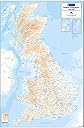
- 1:780000 scale relief map of the United Kingdom
- Includes a height key
- Depicts the land height above sea level
- Map Size 900mm 1300mm
- Ordnance Survey Mapping
- ›See more product details
Material Type:Flat - Face Laminated The Relief Map 1 utilises 1:780,000 scale Ordnance Survey mapping data to provide a clear and easy to use map of the UK with insets for Orkney and Shetland. An easy to use height key shows land height above sea-level across the country. Also noted are national boundaries for England, Scotland and Wales, as well as county boundaries for these areas. The map measures 900mm (width) by 1300mm (height). This version of the Relief Map 1 UK is printed on 100gsm Matt Paper and is finished with a Face Lamination that provides a durable finish which can be used with Dry-Wipe markers. This map is supplied in a tough reusable plastic poster tube.
Common Questions
Trustpilot